
Methane Satellites 101: More Eyes Take to the Skies
Why we need these sky-high sensors, and what we can do with the data.
We are in a race against time to clean up centuries of pollution in our atmosphere and rebalance our climate. While carbon dioxide rightly receives attention as the prime warming culprit, another greenhouse gas — methane — wreaks more havoc in a shorter timeframe than CO2.
Methane’s effect on our atmosphere cannot be overstated. If CO₂ pollution wraps one blanket around the earth, methane pollution is like wrapping the earth in over 80 blankets. The good news is that cutting methane emissions now, before it super-heats the planet, results in immediate climate and public health benefits.
But methane has proven a challenge to track consistently. It’s invisible, for one, as well as odorless, pressurized, and leaky. But we know where to spot it. Methane’s biggest human-caused sources are oil and gas, coal mines, waste facilities, and agricultural operations like large animal feedlots. These emissions can be persistent, like a landfill that spews methane for months on end, or highly intermittent, like a gas flare. Plus, emissions can be big and concentrated (like a super-emitter event) or less concentrated and diffused over a big geographic area. In short, they are highly complex and therefore really tough to track and quantify.
So, where to start? The first step is to better monitor these emitting events, and the facilities where they happen. Until recently, this tracking has been intermittent, with methane surveys mostly taking place on the ground with handheld devices. Other strategies, like aerial flyovers, have helped improve transparency but are not up to the task of monitoring the truly planetary scale of methane pollution and in prioritizing actions that can reduce emissions now.
Now, a new generation of nonprofit (NGO) satellite missions is rising to the challenge. With the launch of MethaneSAT in early March by the Environmental Defense Fund, the first by a non-governmental organization (NGO), there are now more than a dozen satellites scanning the Earth to identify key sources of methane and other climate pollutants.
And MethaneSAT is just the first of other NGO satellites to come. RMI is playing a leading role in this quest. Later this year, Carbon Mapper — an NGO spearheading the first-ever public, private, nonprofit coalition — is working with Planet Labs, a satellite developer, and NASA’s Jet Propulsion Laboratory to launch its first hyperspectral satellite which will detect high emissions point sources of methane (and CO2) acting like a zoom lens that can spot leaks down to a specific facility or piece of equipment with unprecedented precision. RMI is a member of the Carbon Mapper Coalition along with Planet, NASA Jet Propulsion Lab, California Air Resources Board, University of Arizona, Arizona State University, and philanthropic partners.
For global emissions, the wave of new sky-high NGO sensors means that we are closer than ever to getting a handle on the methane menace — and putting a stop to it.
Seeing the invisible
Methane is not visible to the human eye, so how can satellites see it? Fortunately, the technology to allow this is not a giant leap. In fact, it’s available in most college physics labs.
The key sensor, called a spectrometer, works a little like a camera. Point the camera at an area: It will show you an image. Point a spectrometer at an area: It shows the kinds of light that get absorbed by whatever the spectrometer is focused on.
To find methane, we’re looking for a signature pattern that only CH4 — the methane molecule — produces when absorbing sunlight. This pattern is only visible on the infrared spectrum at a particular wavelength.
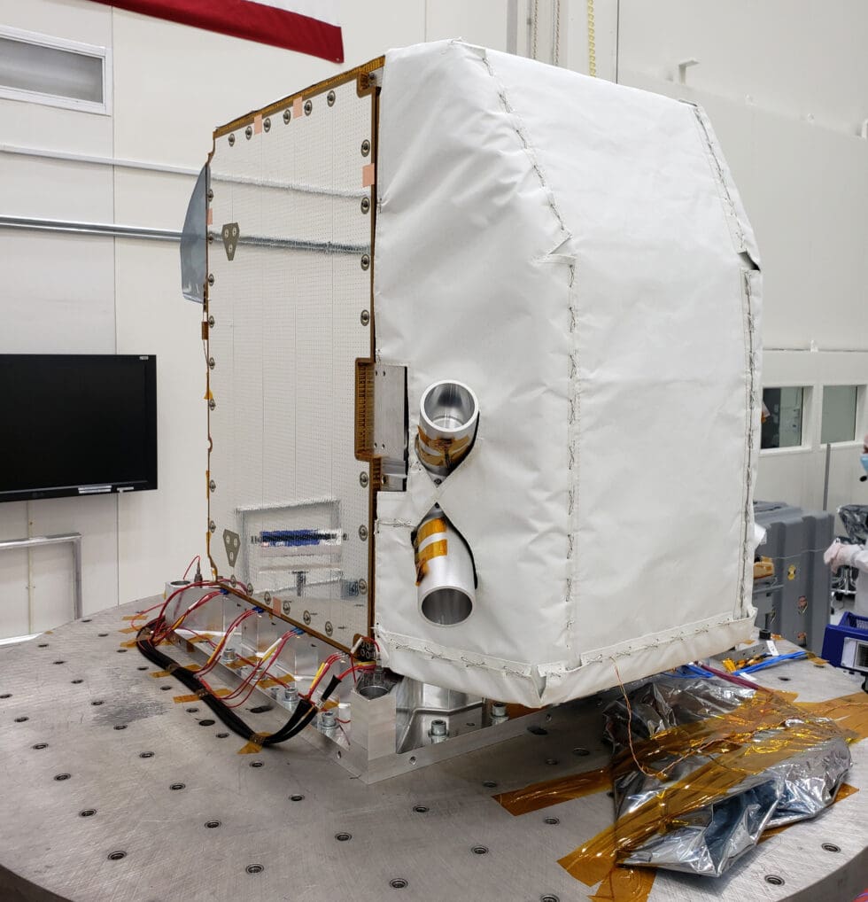
An imaging spectrometer, which will measure the greenhouse gases methane and carbon dioxide, sits integrated at NASA’s Jet Propulsion Laboratory in August, 2023. Source: Carbon Mapper
Scanning the whole planet
To monitor the scale of methane emitters across planet Earth, the spectrometer needs to go high — very high. After months of tests to prove its spaceworthiness — including subjecting it to intense vibrations to simulate a launch as well as the subzero temperatures it will encounter in the vacuum of space — the methane detector is mounted onto a satellite and rocketed into space.
Once anchored in orbit, satellites can begin to search for methane as they swing around the earth.
A satellite flight path demonstration (Source: CarbonMapper).
All the methane they can see
As the scale of the methane problem has become known, governments, nonprofits, and private entities have begun to fill the knowledge gap, all launching their own satellites with unique and complementary capabilities.
Some can see at a continent level (called area flux monitors), while others are able to pinpoint leaks right down to the source (these are called point source monitors). Some can view an area multiple times a day (essential to track variability in leaks), while others can check on a weekly or monthly basis.
Below is the current state of methane detection satellite operations, but the field is growing still. The European Space Agency is set to launch Sentinel-5 this year, with its CO2M satellite following in 2025; while MERLIN, a partnership between the French and German space agencies, is slated for a 2027 launch.
What’s new about nonprofit-led satellites — and what can we do with this data?
Nonprofit-led satellite programs like MethaneSAT and Carbon Mapper fill a crucial gap in our detection capabilities by virtue of their owners. Unlike national operators, no government can cut their funding, and unlike commercial operators, no bottom line need be met. The higher sensitivity of their sensors will also allow these new players to provide more actionable, timely, granular data than is currently on offer. MethaneSAT and Carbon Mapper satellites will also be complementary — with the former able to capture wide areas like basins, and the latter able to focus in on point sources.
Carbon Mapper and MethaneSAT also differ from the public and private options in their mission: these satellites are not for private use or scientific research, they are for climate action. They are open-source by design, helping feed methane measurements into a burgeoning field of independent emissions monitors — like RMI’s OCI+ platform and Climate TRACE — and allowing all stakeholders to benefit, and take action, based on the data returned from the satellites.
With all this information public, it will put pressure on emitters to clean up their acts. And with the US government’s methane fee on the horizon, oil and gas facilities have even more incentive to plug the leaks as quickly as possible.
With no time to lose as we reach crucial climate tipping points, these satellites are an essential tool protecting us and our communities from the aftermath of rising global temperatures. As more eyes take to the skies, methane will be invisible no more.
Read more: